Małopolska Trail of the Holy Sepulchre Order

Budynek kościoła wśród drzew
Bożogrobcy a dokładnie Zakon Rycerski Grobu Bożego w Jerozolimie utworzony został ok 1496 roku z inicjatywy papieża Aleksandra VI. Celem działalności zakonu było propagowanie pielgrzymowania możnowładców do Ziemi Świętej. Choć niewielu rycerzy polskich było uczestnikami tych pielgrzymek oraz wypraw krzyżowych, to Małopolski Szlak Bożogrobców jest trasą, która prezentuje historię i rolę zakonu w dziejach Kościoła i kultury polskiej.
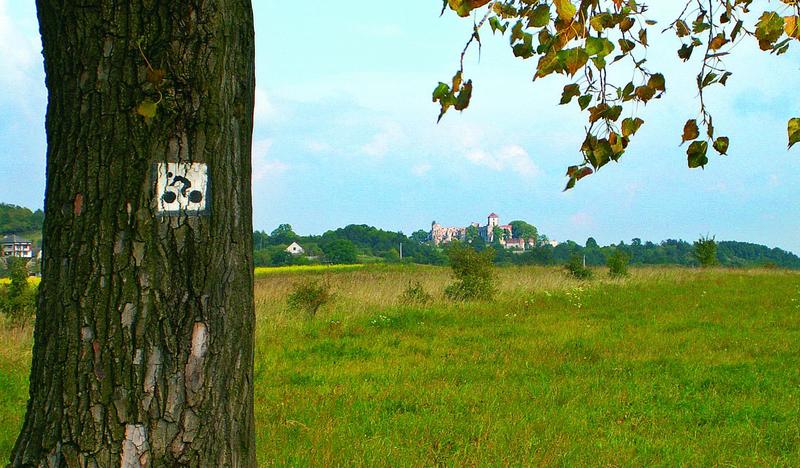
Almost nine hundred years ago Knight Jaksa Gryfita returned from a crusade to the Holy Land. He brought along the Canon Regulars of the Holy Sepulchre, known in Poland as the “Holy Sepulchrists” [bożogrobowcy] or “Miechovites” [of Miechów]. Despite the Holy Sepulchre Order’s absence in Poland, since the monastery’s liquidation in 1819, the memory of their legacy, as well as the sites associated with them have prevailed until now. Their legacy in Małopolska has been marked by the Trail of the Holy Sepulchre Order. The trail starts at the Sanctuary of the Holy Sepulchre in Miechów. It then continues to churches in Siedliska, Uniejów, Chodów, Sławice and Wrocimowice in the vicinity of Miechów, and then arrives in Krakow where the Holy Sepulchre monks cared for St. Barbara’s Church, among others. The trail ends at the church in Chełm near Bochnia.

 
Download free VisitMałopolska app
 
Android
Apple iOS
Windows Phone
<
>
   
Back

Jura Upland Bicycle Trail of the Eagles’ Nests (Małopolska region section)

Jura Upland Bicycle Trail of the Eagles’ Nests (Małopolska region section)

zamek
The Trail of the Eagles’ Nests is a must for every fan of cycling. The trail meanders around the recesses of the Kraków-Częstochowa Upland, presenting what it has the best to offer, i.e. ruins of castles and endless forests, e.g. the Dulowska Forest.
Difficulty: Medium
Trail length: 89,1 km
Facilities: Camping sites, Place for a bonfire, Viewpoints, Information boards, Educational paths

The section in the Małopolska region is mostly devoid of what is most characteristic of the Silesian part of this trail, i.e. a large number of sandy fragments. Of course, we also come across them, but they are not really long. Anyway, for this trail we recommend a bike with wide tires (mtb / tourist / gravel). The trail is very well marked, there are several resting places along the way with information boards and mileage boards. Up to Krzeszowice the trail runs practically parallel to the trail of the future VeloRudawa route and the railway line.

The maximum altitude is: 464 m asl. The lowest point on the route is at an altitude of 207 m asl.

The trail runs 44% on roads separated from car traffic. 44% of the route runs through forest.

The route runs through the following protected areas:

Landscape Parks: Eagles' Nests Landscape Park, Krakow Valleys Landscape Park, Tenczynek Landscape Park

Reserves: Eliaszówka Valley

Natura 2000: Jurassic Valleys, Jaroszowiec, Czerna, Krzeszowice, Ostoja Środkowojurajska

Tourist attractions: Wooden Villa from 1896 (Zabierzów), Carmelite Museum in Czerna (Krzeszowice), Museum of the Krzeszowice Land (Krzeszowice), Potocki Palace in Krzeszowice (Krzeszowice), Vauxhall Palace (Krzeszowice), Rabsztyn Castle ( Olkusz), Tenczyn Castle (Krzeszowice), Castle in Bydlin (Klucze).


Natural attractions: Natura 2000 – Czerna, Natura 2000 – Jurassic Valleys, Natura 2000 – Jaroszowiec, Natura 2000 – Krzeszowice, Natura 2000 – Ostoja Środkowojurajska, Eliaszówka Valley Nature Reserve, Racławka Valley Nature Reserve, Ruskie Góry Nature Reserve, Skała Kmita Nature Reserve, Smoleń Nature Reserve, Krakow Valleys Landscape Park, Eagle Nests' Landscape Park, Tenczynek Landscape Park.

Facilities: Camping sites, Place for a bonfire, Point of observation, Viewpoints, Information boards, Shelters, Educational paths
Type of surface: unimproved dirt road, improved dirt road, asphalt (even), asphalt (poor quality), concrete cube